
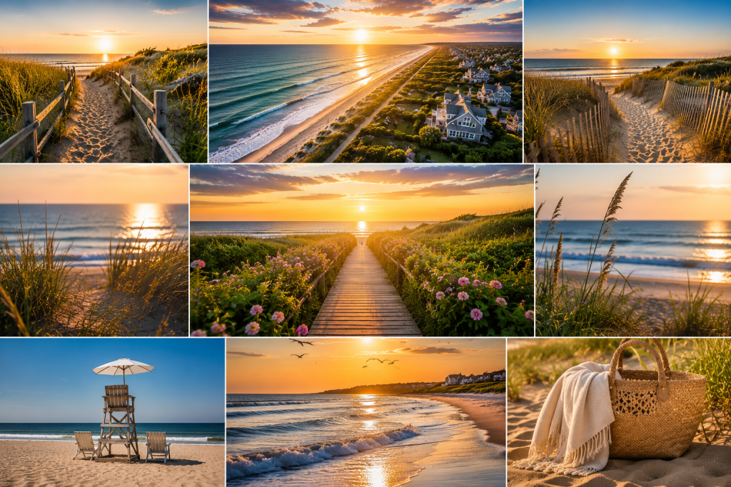
The Coastline That Named a Hamlet
The Montaukett people named this place for its water. “Amagansett” translates to “place of good water,” and the freshwater spring they prized sits near what is now Indian Wells Beach. Three centuries later, the Amagansett beaches remain the hamlet’s defining feature, yet they operate on a principle that separates them from every other stretch of Hamptons coastline. There are no cabanas for rent. No bottle service at the waterline. No branded tents with DJs playing tech house to a curated crowd. Instead, what you get is sand, ocean, and the quiet understanding that this is a beach, not a venue.
For the Park Slope family that summers in Amagansett, this distinction is the entire point. Compare these beaches to Cooper’s Beach in Southampton, where the parking lot costs $50 and the social hierarchy is visible from the dune line. Or to the Hamptons beach club circuit, where membership fees determine who swims where. In Amagansett, the beach is public, the parking requires a Town of East Hampton sticker (or a daily fee in season), and the ocean treats everyone with identical indifference. Essentially, the democracy starts at the tide line.
Indian Wells Beach: Where the Name Began
Indian Wells Beach sits on the site of the freshwater spring that gave Amagansett its name. The Montaukett people drew water here for centuries before the first European settlers arrived in 1680. Today, it is the hamlet’s most popular ocean beach: wide sand, strong surf, lifeguards from Memorial Day through Labor Day, a large parking lot, and restroom facilities. The swimming is notably clean and consistent, a fact the Montaukett understood before anyone else articulated it.
What separates Indian Wells from comparable beaches on the South Fork is the scale of what’s missing. There is no boardwalk. No concession stand selling overpriced smoothies. No beach club entrance requiring a membership card or a net worth above a certain threshold. Instead, what you get is a wide stretch of Atlantic sand bookended by dunes, with the Amagansett National Wildlife Refuge visible to the east. For the Carroll Gardens architect who designs access-controlled environments, Indian Wells represents a radical proposition. A public beach can simply be public. Naturally, there are no gates. No velvet rope in sand form. Just ocean, for everyone.
The Asparagus Beach Era
In the 1970s, locals nicknamed Indian Wells “Asparagus Beach” because singles would stand in upright clusters along the shoreline, spaced closely together, scanning the crowd for dates. The image is vivid enough that it stuck for decades. Indeed, the nickname says more about the beach’s social function than any tourist brochure could. Indian Wells has always been the Amagansett beach where people come to be seen (or to see), even if the seeing is done with the relaxed casualness that distinguishes this hamlet from every other East End community. Today the singles scene has migrated largely to apps, but the clustering instinct remains. Families claim territory near the lifeguard stands. Surfers drift toward the eastern edge. Couples settle in the middle distance. The beach sorts itself without instruction.
The Park Slope pediatrician arrives at Indian Wells at 9:15 a.m. on a Saturday in July.
Her husband sets up the umbrella while their daughter sprints toward the water.
She looks east. Sand, sky, and the Walking Dunes in the distance. Nothing else.
Not a single cabana. No bottle service. No DJ.
“This is what Cooper’s Beach used to feel like,” she tells her husband.
He doesn’t look up from the sunscreen. “Cooper’s never felt like this.”
He’s right. This is something older. Something the Montaukett would recognize.
Good water. It was always the thesis.
Atlantic Avenue Beach: Where History Landed
Atlantic Avenue Beach sits roughly a mile east of Indian Wells, and for most visitors it functions as the quieter alternative: fewer crowds, a slightly more local feel, families who prefer the mellower energy. However, Atlantic Avenue Beach holds one of the most extraordinary stories in American military history, and almost nobody sunbathing there knows it.
The Night of June 12, 1942
On that night, the German submarine U-202 surfaced off Amagansett and four Nazi saboteurs rowed an inflatable raft to this exact beach. Operation Pastorius, as it was called, was designed to sabotage U.S. infrastructure. The saboteurs carried $175,000 in cash and enough explosives for a two-year campaign. A 21-year-old Coast Guard patrolman named John Cullen, armed with nothing but a flashlight and a flare gun, stumbled into the landing party. The lead saboteur tried to bribe him with $260 in cash. Cullen took the money and ran to the station. Consequently, the operation collapsed within two weeks, and six of the eight agents were executed.
Today, the East Hampton Town Marine Museum sits on nearby Bluff Road, housing whaling relics and a cannon recovered from HMS Culloden, a British warship that ran aground off Montauk Point in 1781. The original Coast Guard station was moved to a private residence in 1966 and then restored near its original Atlantic Avenue location in 2007. Still, there is no plaque on the beach marking where the spies came ashore. No interpretive sign. No walking tour. Amagansett’s relationship with its own history is consistent: the story is enormous, and the signage is nonexistent.
The Wildlife Refuge: 36 Acres Between Two Beaches
Between Indian Wells and Atlantic Avenue beaches lies the Amagansett National Wildlife Refuge, a 36-acre federal preserve acquired in 1968. It is one of the last undeveloped stretches of oceanfront on the South Fork, and it contains a unique double dune system that has been lost to development on most of Long Island. In spring and summer, the secondary dunes and swale display rare orchids, wildflowers, and coastal grasses. The refuge is a prime stopover for migrating raptors, shorebirds, and songbirds, including the federally threatened piping plover and the state-threatened least tern.
Access and Restrictions
The beach section of the refuge is open to the public, but the back dune area is permanently closed to entry. Additionally, public beach access shuts down entirely from late March through August 31 to protect nesting shorebird habitat. This seasonal closure is not a suggestion. It is federal law. For birders and naturalists, the refuge offers some of the best wildlife observation on the East End. For everyone else, it is the green stripe between two popular beaches, a visual reminder that this coastline was not always (and does not have to be) a recreational product. Notably, the refuge receives no government operating funding and relies entirely on the U.S. Fish and Wildlife Service’s broader budget allocations.
Napeague: The Threshold and the Walking Dunes
East of the Amagansett crossroads, Montauk Highway narrows and the landscape shifts. The Napeague stretch is a sand bridge that connects the rest of Long Island to Montauk, and geologically it exists because Montauk was once an island. Over thousands of years, ocean currents deposited sand in the gap. The result is Napeague: narrow, wind-swept, and home to one of the most unusual geological formations on the East Coast.
The Dunes That Move
The Walking Dunes at Napeague State Park are parabolic sand dunes. They migrate steadily, driven by prevailing winds. As they move, they bury pine forests on their leading edge and reveal previously buried landscapes on their trailing edge. The effect is surreal: living trees half-swallowed by sand, ghost forests emerging from dunes that have passed. Hiking trails wind through the formation, and on a weekday morning in early June, you might walk the entire loop without seeing another person. For the Cobble Hill landscape architect who spends her professional life designing controlled environments, the Walking Dunes are a corrective. Nature here is doing exactly what it wants. Nobody asked permission. Nobody filed a plan.
Napeague’s beaches are longer, emptier, and less structured than the main Amagansett beaches. There are no lifeguards, no bathrooms, and no concessions. Beach Hampton, the neighborhood wedged between the ocean and Montauk Highway in the Napeague stretch, offers access to some of the quietest oceanfront sand on the South Fork. In summer, this area is popular with campers at nearby Hither Hills State Park, but the beach itself rarely feels crowded. For the person who wants an Atlantic swim without any of the infrastructure that typically accompanies it, Napeague is the answer.
Geographically, Napeague represents the threshold between “the Hamptons” and “the end.” When you drive through the stretch on Route 27, you feel the shift. The commercial density drops to zero. Scrub pine replaces hedgerow. The Atlantic becomes visible on both sides of the road simultaneously, a phenomenon that occurs nowhere else on the South Fork. This is where the island narrows to its thinnest point. The landscape communicates something the GPS cannot: you are leaving one version of Long Island and entering another.
Standing at the Edge
For many Amagansett regulars, a Sunday morning walk on the Napeague beach is less about swimming than about standing at the edge of something. One edge is the Hamptons. Another is the island itself. And then there is the edge of whatever it is you drove two hours to escape.
Albert’s Landing: The Bayside Secret
Amagansett’s ocean beaches get the attention, but the hamlet also touches Napeague Bay on its northern edge. Albert’s Landing, located near Fresh Pond Park, offers calm, shallow water with views across the bay. The swimming is gentler here, the waves essentially nonexistent. Families with young children gravitate toward the bay side. The calm water is exactly the reason. Additionally, Albert’s Landing is a reliable spot for bird watching and crabbing, two activities that require patience, quiet, and the willingness to sit still for an hour without checking your phone.
Compare that experience to the ocean beaches on the south side, where the surf demands attention and the energy is kinetic. Albert’s Landing operates in a different register. It is contemplative where Indian Wells is social, still where Atlantic Avenue is historic. In fact, the bayside represents a version of Amagansett that most visitors never discover because they never drive north of the highway. Undoubtedly, their loss.
How Amagansett Beaches Compare
In the broader Hamptons beach landscape, Amagansett occupies a specific niche. Cooper’s Beach in Southampton has been ranked among the best beaches in America by multiple publications, and the ranking is deserved. However, Cooper’s Beach comes with Southampton’s social apparatus: the parking hierarchy, the proximity to the Bathing Corporation, the awareness that the hedgerowed estates of Gin Lane are watching from above. Similarly, the beaches near Bridgehampton are beautiful but exist in the shadow of the event calendar. Sag Harbor‘s Long Beach is a bayside alternative, calmer but smaller.
The Amagansett Difference
Amagansett’s beaches carry no social freight. There is no beach club sorting the crowd into tiers. No charity fundraiser claiming a section of sand for a branded event. No Instagram-famous stretch where influencers congregate for content. Instead, what you get is a coastline that operates the way coastlines operated before the concept of “beach lifestyle” became a marketing category. Certainly, the sand is excellent. Water is clean. Dunes are protected. And the hamlet behind the beach has decided, collectively and without a vote (because there is no village government to hold one), that the beach is not a product. It is a place. After all, the Montaukett named it for the water, not for the experience.
The Practical Guide: Parking, Access, and Timing
Amagansett’s beaches fall under the Town of East Hampton’s jurisdiction. Parking requires a town beach sticker (available to residents and seasonal renters) or a daily parking fee during summer season. The daily fee at Indian Wells and Atlantic Avenue can reach $30 to $50 on peak weekends. Certainly, arriving early matters: by 10 a.m. on a Saturday in July, the Indian Wells lot is often full.
When to Go
The best Amagansett beach days follow a simple schedule. Arrive before 9:30 a.m. for parking. Swim at Indian Wells if you want lifeguards and the social scene. Walk east to the Wildlife Refuge if you want solitude and birding. Drive to Napeague if you want empty sand with no infrastructure. Take young children to Albert’s Landing on the bay side for calm water. After the beach, stop at LUNCH Lobster Roll or the Clam Bar at Napeague on the drive back. Close the evening with dinner at Il Buco al Mare or a burger at Rowdy Hall. This is the rhythm. After a few summers, it becomes instinct.
The Murray Hill radiologist parks at Indian Wells at 8:45 a.m. on a Friday.
His wife is already in the water by the time he finishes applying sunscreen to the twins.
He looks east toward Napeague. Sand, sky, dunes. Zero infrastructure.
He came to the Hamptons expecting something produced. Something branded.
What he found was a beach that existed before the word “brand” did.
His wife waves from the surf. The twins are already covered in sand.
He closes his eyes. The sound is wind, water, and children laughing.
Good water. Three hundred years later, still the whole story.
Where the Conversation Continues
Social Life Magazine has covered the East End’s coastline for 23 years. Five summer issues, 25,000 copies each, distributed from Westhampton to Montauk in the restaurants, hotels, and beach clubs where the Hamptons conversation happens. If your brand lives at the waterline, we speak your language.
If your brand serves the Amagansett beach audience (sunscreen, swimwear, outdoor gear, wellness, family hospitality, surf culture), a feature in Social Life Magazine reaches the people already on the sand. Learn more at sociallifemagazine.com/submit-a-paid-feature.
Polo Hamptons 2026 returns to Bridgehampton on July 18 and July 25. BMW North America is title sponsor. Christie Brinkley hosts. After the beach, the polo field. Reservations at polohamptons.com.
Subscribe at sociallifemagazine.com/subscription for every issue.
The Montaukett named it for the water. The water hasn’t changed its mind.
Author

Written by
Recent Posts
Proteus: Fabien Cousteau’s $135 Million Underwater Bet
Fabien Cousteau’s Origin Story: Barnacles Before the Throne
Fabien Cousteau Is Building the Ocean’s Space Station

The Hamptons Sharehouse Is a Hedge Fund With Beds

The Maître D’ at the Restaurant Door Has All the Power
Categories
- Art
- Articles
- Business of Luxury
- Celebrities
- Entertainment
- Events
- Faces of Summer 2026
- Fashion
- Fashion & Style
- Featured
- Finance
- Food, Spirits, Wine
- Hamptons
- Hamptons Celebrities
- Health
- Health & Beauty
- Lifestyle
- Luxury Lifestyle
- Press
- Profiles
- Real Estate
- Technology
- The Chronicles
- Travel
- Uncategorized
- Weddings